Anthropocene | T.J. Demos | Tuesday, 05.05.2015
Welcome to the Anthropocene!
"In a single lifetime we have grown into a phenomenal global force. We move more sediment and rock annually than all natural processes such as erosion and rivers. We manage three quarters of all land outside the ice sheets. Greenhouse gas levels this high have not been seen for over one million years. Temperatures are increasing. We have made a hole in the ozone layer. We are losing biodiversity. Many of the world’s deltas are sinking due to damming, mining and other causes. Sea level is rising. Ocean acidification is a real threat. We are altering Earth’s natural cycles. We have entered the Anthropocene, a new geological epoch dominated by humanity."
So explains the commentary of the video, Welcome to the Anthropocene, which claims to be the “world's first educational webportal on the Anthropocene,” commissioned by the 2012 Planet Under Pressure conference that occurred in London, and developed and sponsored by the www.anthropocene.info organization, an educational site dedicated to popularizing scientific discourse.1Sponsors include The International Geosphere-Biosphere Programme, Stockholm Resilience Centre of Stockholm University, Australia’s Commonwealth Scientific and Industrial Research Organisation, The International Human Dimensions Programme on Global Environmental Change, and Globaïa. As of May 4, 2015, the http://www.anthropocene.info/ website has encountered unspecified problems and is unavailable. The video is found at: https://www.youtube.com/watch?v=fvgG-pxlobk. Apparently, just like that, we’ve found ourselves in a new geological epoch, even though, if we look further into what this era is and how it's defined, it turns out that, for some scientists, the period began more than 200 years ago with the beginning of the industrial revolution, while according to others, its origins stretch back thousands of years to the dawn of human agriculture (still others suggest it coincides with the nuclear era). Notwithstanding the fact that this geological designation still awaits official confirmation by the Subcommission on Quaternary Stratigraphy’s Working Group on the “Anthropocene,” we might pause to ask: how does this new epoch—if it is indeed granted epoch-status—and its discursive framework relate to image technologies, including the photographic? This question represents the overarching inquiry I’ll consider over my forthcoming series of posts.
As explain the partners of this particular public-relations project, one of many now dedicated to publicizing the Anthropocene (according to diverse purposes and agendas), the term was coined by atmospheric chemist Paul Crutzen and biologist Eugene Stoermer in 2000 to designate the present era, which, for them, has overtaken the Holocene that has been in existence for the last 11,700 years. The shift owes to “human activities,” which have become the central driver of geologically significant conditions and processes in our present.2See http://www.anthropocene.info/en/glossary The changes include alterations to the chemical composition of the atmosphere, oceans, and soils, bringing about many ecological transformations such as global warming, ocean acidification, expanding oceanic “dead zones,” and increased species extinction owing to habitat loss and environmental destruction, which are at the forefront of current ecological and political debates.
First broached in the natural sciences and propelled further in popular science educational media, the Anthropocene has already become part of an expanding discourse in the arts and humanities, debated recently by figures like Bruno Latour and Donna Haraway, and taken up in cultural practices, exhibitions, and publications, such as Berlin’s House of World Culture’s 2013-14 “Anthropocene Project,” and the forthcoming compilation volume Art in the Anthropocene: Encounters Among Aesthetics, Politics, Environments and Epistemologies, edited by Heather Davis and Etienne Turpin. These contributions—more on which later—alone make it worthy of our attention. It also remains urgent to bring these critical humanities-based resources to bear on scientific discourse in order to disrupt specialist divisions, democratize debate, and pose critical questions of political significance to discussions regarding environmental developments that in one way or another are having major, if differentiated, impacts on the lives of all. So what are the Anthropocene’s politics of representation?
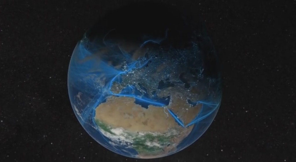
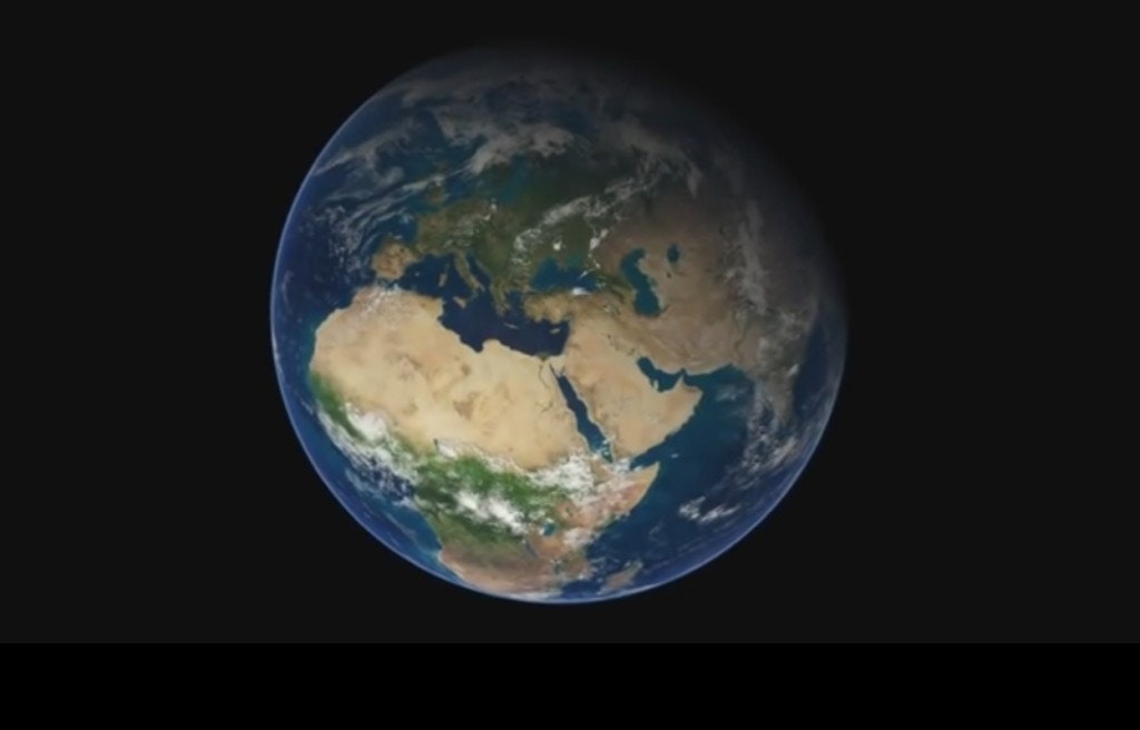
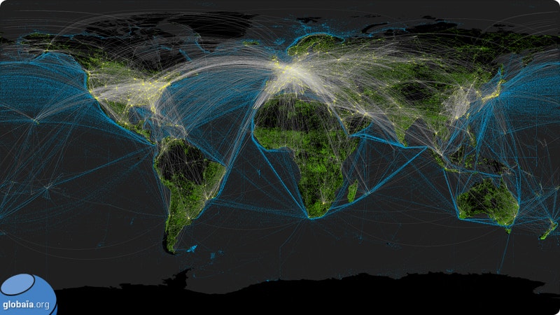
Welcome to the Anthropocene offers an authoritative voice-over commentary that narrates a shifting data visualization of the globe, showing schematic networks of light trajectories that reference energy, transportation and communication systems. The same visual information is presented on Globaïa’s “Cartography of the Anthropocene” website, an organization related to the umbrella organization responsible for the video, one “dedicated to fostering awareness among citizens by promoting the emergence of a global vision of our world and of the great socioecological challenges of our time.” The Cartography offers a series of images with various representational modalities, showing cities, shipping and air transportation routes, pipelines, and submarine fiber-optic cable systems. The presentation charts the interconnected networks of “human activities” that show how “we have grown into a phenomenal global force,” even while many humans would certainly resist identifying with the collective “we” of the implied Anthropocene subject.
Such imagery speaks to a problem articulated by recent theorists of ecology—that the expanded spatial and temporal scales of geology pressure, if not altogether exceed, human comprehension, and thereby present major challenges to representational systems.3Timothy Morton, Hyperobjects: Philosophy and Ecology after the End of the World (Minneapolis: University of Minnesota Press, 2013); and Elizabeth Ellsworth and Jamie Kruse, eds., Making the Geologic Now: Responses to Material Conditions of Contemporary Life (Brooklyn, NY: Punctum, 2012). For once we start talking about the massively distributed and temporally extended “hyperobjects” of geology, to use a term of Timothy Morton, the minute-by-comparison pictorial conventions of landscape photography—even those of photography at large—suddenly become far from adequate.
Anthropocene visualizations are significant in that they often don’t employ photography as their visual medium of choice, but rather high-resolution satellite imagery that provides photographic-like pictures. That’s important insofar as—at least in relation to much scientifically-framed imagery, maps, and data graphs—we’ve moved essentially beyond photography (gauged to human perception) to remote sensing technology (scaled to global, even inter-planetary visualizations). Seemingly existing as self-evident pictures, satnav imagery resembles and is often taken for photography, but actually comprises a composite set of digitized files, the result of processed quantities of remotely sensed data collected by satellite-based sensors.4For Laura Kurgen, writing in Close Up At A Distance: Mapping, Technology & Politics (Cambridge, Mass.: Zone, 2014), we have recently undergone “a cataclysmic shift in our ability to navigate, inhabit, and define the spatial realm...brought on by: the operationalizing of Global Positioning System (GPS) satellites for both military and civilian uses in 1991; the democratization and distribution of data and imagery on the World Wide Web in 1992; the proliferation of desktop computing and the use of geographic information systems for the management of data; the privatization of commercial high-resolution satellites later in the 1990s; and widespread mapping made possible by Google Earth in 2005,” (14). In most cases regarding lay usage, these images have also already been interpreted for viewers (or rather consumers), packaged as pictures, without offering access to location data, ownership, legibility, and source information.5http://globaia.org/portfolio/cartography-of-the-anthropocene/, however, does provide the following note on its use of data: “DATA SOURCE: Paved and Unpaved Roads, Pipelines, Railways & Transmission Lines: VMap0, National Geospatial-Intelligence Agency, September 2000. Shipping Lanes: NOAA’s SEAS BBXX database, from 14.10.2004 to 15.10.2005. Air Networks: International Civil Aviation Organization statistics. Urban Areas: http://www.naturalearthdata.com/. Submarine Cables: Greg Mahlknecht’s Cable Map. Earth texture maps: Tom Patterson. Anthropocene Indicators: Global Change and the Earth System: A Planet Under Pressure, Steffen, W., Sanderson, A., Jäger, J., Tyson, P.D., Moore III, B., Matson, P.A., Richardson, K., Oldfield, F., Schellnhuber, H.-J., Turner II, B.L., Wasson, R.J.”
Yet while visual imagery has been central, even integral to the process of conceptualizing the Anthropocene, scientific popularizers rarely evince awareness of the use of such imagery, or of the political implications of their representations, which not only help illustrate geological concepts, but also frame them in particular ways, ways that are deeply political. As well, those images bear the potential to be read differently, potentially contesting and complicating some of the Anthropocene theory’s basic claims, if analyzed critically.
One problem with the term Anthropocene lies at the very root of the term, anthropos (ancient Greek for “man” or “human being”), implying that it is “human activities” that are responsible for this new geological epoch, a common formulation found in the literature (for instance in the anthropocene.info website, in the video Welcome to the Anthropocene, and in Crutzen and Stoermer’s original essay6See Eugene F. Stoermer and Paul Crutzen, “The ‘Anthropocene’,” Global Change Newsletter 41 (2000), 17–18.). Yet the “activities” that are shown in the imagery that commonly depicts the said epoch are hardly “human,” at least in that generalizing, species-being sense, but are in fact mostly the “activities” of corporate industry, an area generally occluded in Anthropocene discourse. This simple fact leads us to ask what ideological function does “Anthropocene” serve—terminologically as well as conceptually, politically as well as visually—in relation to the current politics of ecology, and how does the expanded imagery of what was once “photography” abet or complicate this function?
As is well known by some, the data visualization tools used by the Globaïa website, like Google Earth mapping imagery more generally, are embedded in a specific political and economic framework of our present, comprising a visual system delivered to us and constituted by a military-state-corporate apparatus, which offers an innocent-seeming picture that is in fact a “techno-scientific, militarized, ‘objective’ image.”7Kurgen, Close Up At A Distance, 30. Also see http://www.fotomuseum.ch/en/explore/still-searching/articles/26980_geographies_of_photography, one of Trevor Paglen’s 2014 Winterthur blog posts, where he importantly points out that satellite imagery is “produced by and, in turn, productive of an enormous relational geography with political, economic, legal, social, and cultural aspects.”) I wonder to what degree the Anthropocene is a function of that system, despite its scientific terminological origins (a question to which I will return in future postings). My hunch is that “Anthropocene” rhetoric frequently acts as a mechanism of universalization, albeit complexly mediated and distributed among various agents, which enables that military-state-corporate apparatus to disavow responsibility for the differentiated impacts of climate change, effectively occluding the accountability behind the mounting eco-catastrophe.
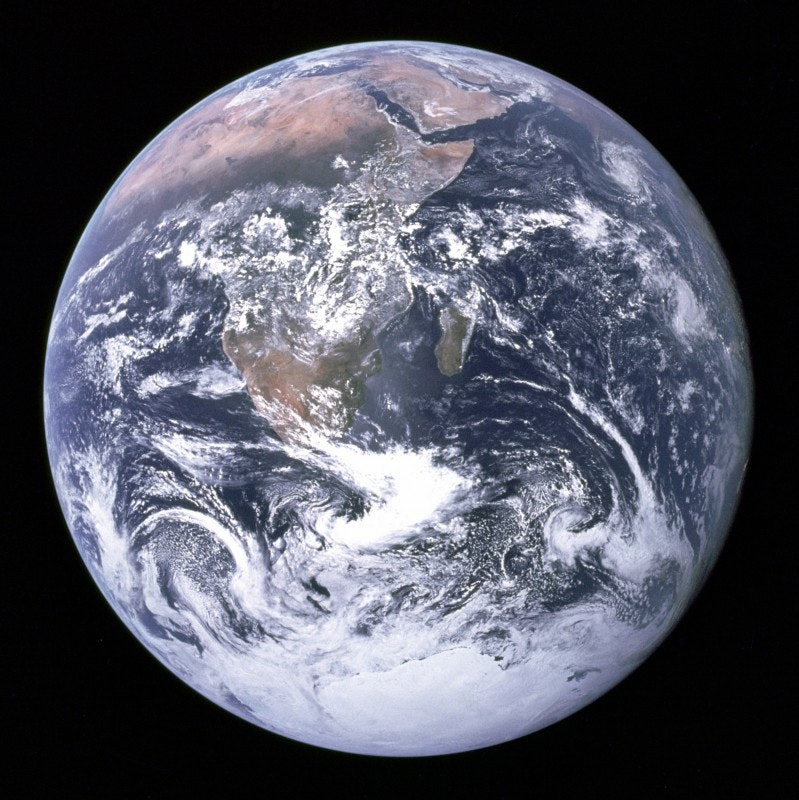
One quick observation: images of a global scale were first produced around 1972, when the first photograph of the whole Earth, the famous Blue Marble image, was taken by NASA astronauts with a 70-millimeter Hasselblad camera aboard the Apollo 17 spacecraft (though Buckminster Fuller correctly pointed out at the time that the image is far from “whole” and in fact shows only half the planet). The image answered calls, famously voiced by Whole Earth Catalogue publisher Stewart Brand, as well as others,8For instance, Frank Borman, Apollo 8 mission commander, made this comment upon seeing the first image of the earth from outer space taken in 1968: “When you’re finally up at the moon looking back at the earth, all those differences and nationalistic traits are pretty well going to blend and you’re going to get a concept that maybe this is really one world and why the hell can’t we learn to live together like decent people?” Cited in Denis Cosgrove, Apollo’s Eye: A Cartographic Genealogy of the Earth in the Western Imagination (Baltimore: Johns Hopkins University Press, 2001), 258. for a unifying “world perspective” that could bring Earthlings together visually, facilitating a new era of global peace based on a shared planetary identity that would overcome the political, social, national and other divisions then rocking the planet (including Cold War conflicts, the American war in Vietnam, military dictatorships in Latin America, civil rights struggles in Apartheid South Africa, socio-political upheavals in Europe and the US, and tumultuous processes of decolonization in Africa and Asia). “If we are to have peace on earth,” intoned Martin Luther King Jr. in 1967, “we must develop a world perspective.”
King’s “world perspective,” approximated by the remarkable Apollo 17 image, catalyzed hopes for human unification even though its view, shot from seemingly nowhere, also negates specific agency. Today, however, Anthropocene images tend to be pitched in very different ways, foremost among them: to raise awareness of the “human activities” that have disrupted the Earth’s natural systems; and to demonstrate the achievements and impacts of the human mastery of the planet via geoengineering, which is often pitched as our only remaining hope (contested by activists who argue for “system change, not climate change”).9See Clive Hamilton, Earthmasters: The Dawn of the Age of Climate Engineering (New Haven: Yale University Press, 2014); and http://systemchangenotclimatechange.org/. But Anthropocene discourse also tends to disavow differentiated responsibility for those geological changes, avoiding the politicization of ecology that could lead to forms of climate justice. How does that disavowal operate? How might it be challenged photographically or via photographic-like imagery? And what would it mean to politicize the visual culture of the “Anthropocene”?